
Wandkaarten van landen
Wandkaart van de wereld kopen? Laat uw interieur de grenzen verleggen met onze collectie landkaarten
Heeft u een speciale band met een bepaald land of vindt u de vorm van Groot-Brittannië gewoon erg mooi bij uw interieur staan? Er zijn landkaarten van veel verschillende landen: van Alaska tot Australië. De meeste zijn zeer gedetailleerd en geven steden, wateren, bergruggen en grenzen aan, sommige geven slechts lijnen en kunt u zelf inkleuren.
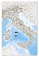 Wandkaart Italy – Italië, 59 x 87 cm | National Geographic
Decoratieve wandkaart van Italië. Naast de mooie kleuren staan er bijzonder veel plaatsen op vermeld. This Italy Wall Map by National Geographic contains extensive political information with political boundaries clearly …
★★★★★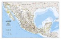 Wandkaart Mexico, 78 x 54 cm | National Geographic
Decoratieve wandkaart van Mexico. Naast de mooie kleuren staan er bijzonder veel plaatsen op vermeld. This finely detailed National Geographic political map of Mexico shows country boundaries, cities and towns, …
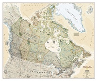
★★★★★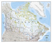 Wandkaart Canada, 97 x 82 cm | National Geographic
Decoratieve wandkaart van Canada. Naast de mooie kleuren staan er bijzonder veel plaatsen op vermeld. This beautiful wall-map from National Geographic depicts Canada and the areas surrounding the Great Lakes …
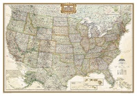 Wandkaart USA - Verenigde Staten politiek, antiek, 108 x 75 cm | National Geographic
Wandkaart van de USA waarbij de kleuren in 'antieke' look zijn weergegeven, de staatgrenzen zeer duidelijk zijn en er veel plaatsen op staan. This Antique-style USA Wall Map by National …
★★★★★★★★★★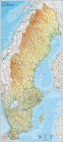 Wandkaart Zweden, 79 x 177 cm | Norstedts
Een grote kaart van Zweden voor aan de muur. Decoratieve kleuren tonen verschillende hoogten en Zweedse bergketens. Belangrijke wegen, spoorwegen en steden zijn duidelijk herkenbaar. Wordt geleverd op rol …
★★★★★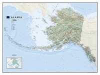 Wandkaart Alaska, 103 x 78 cm | National Geographic
Deze wandkaart van National Geographic is zeer gedetailleerd en bevat alle belangrijke plaatsen. Daarnaast is er ruimte voor de landschappelijke details zoals hoogtelijnen, rivieren, belangrijke wegen en andere items zoals …
★★★★★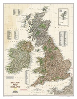 Wandkaart Groot Brittannië en Ierland antiek, 60 x 76 cm | National Geographic
This map of Britain and Ireland shows country boundaries, thousands of place names, major roadways, airports, bodies of water, and more. Rich earth-toned colors, astounding detail and boardroom quality make …
★★★★★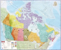 Wandkaart Canada, 120 x 100 cm | Maps International
Mooi, heldere wandkaart van Canada. This Canada wall map clearly depicts all the cities, major roads and also shows all the Provinces and Territory boundaries. All major cities and …
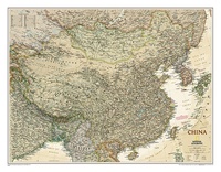
★★★★★★★★★★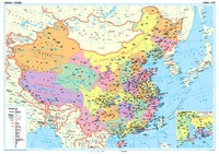 Wandkaart China – political, 95 x 69 cm | Gizi Map
Een wandkaart van China waarop de politieke grenzen en steden tweetalig staan weergeven. Natuurkundige aspecten zijn weggelaten, maar dat komt de politieke en bestuurlijke indeling duidelijk ten goede. Afmetingen: 69cm.x …
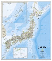 Wandkaart Japan, 63 x 74 cm | National Geographic
This classic-style map of Japan shows political boundaries, major highways and roads, cities and towns, airports, and other geographic details. Thousands of place-names and exact borders are carefully researched by …
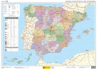 Wandkaart Spanje, 70 x 50 cm | CNIG - Instituto Geográfico Nacional
Administrative provinces of Spain shown in bright colours on a wall map at 1:2,250,000, size 70 x 50cm (27.5" x 20" approx), from IGN/CNIG - the country’s civilian survey organization, …
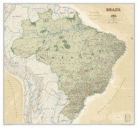 Wandkaart Brazil - Brazilië, politiek & antiek, 104 x 97 cm | National Geographic
Presented in National Geographic’s classic wall map style, our large, earth-tone Brazil wall map is ideal for home or office. Inherent to all National Geographic reference cartography, this map contains …
 Wandkaart Canada, antiek, 97 x 82 cm | National Geographic
Our most detailed wall map of Canada, features the classic National Geographic reference styling. Features thousands of place names, accurate political boundaries, national parks, archeological sites, and major infrastructure networks …
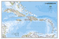 Wandkaart Caribbean – Caraïben, 91 x 61 cm | National Geographic
Completely redesigned and updated, National Geographic Maps' Caribbean Classic wall map is one of the most authoritative maps for the islands of the Caribbean Sea. This new edition shows the …
 Wandkaart China, antiek, 76 x 59 cm | National Geographic
This detailed political map of China accurately shows locations of provincial boundaries, cities and towns, major highways and roads, rivers and waterways, and other geographic features.
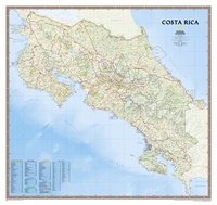 Wandkaart Costa Rica, 97 x 92 cm | National Geographic
Decoratieve wandkaart van Costa Rica. Naast de mooie kleuren staan er bijzonder veel plaatsen op vermeld. This full-color map is a richly detailed rendering of one of Central America's …
★★★★★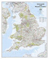 Wandkaart Engeland en Wales, 76 x 92 cm | National Geographic
This classic-style map of England and Wales shows political boundaries, major highways and roads, cities and towns, airports, and other geographic details. Thousands of place-names and exact borders are carefully …
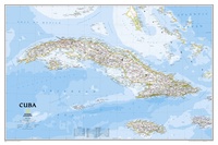 Wandkaart Cuba, 92 x 61 cm | National Geographic
The most accurate and richly detailed reference map available for the iconic Caribbean island nation, our Cuba Classic Map contains National Geographic’s proprietary fonts and world recognized border bands in …
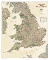 Wandkaart Engeland en Wales, antiek, 76 x 91 cm | National Geographic
This earth-toned, executive-style map of England and Wales shows political boundaries, major highways and roads, cities and towns, airports, and other geographic details. Thousands of place-names and exact borders are …
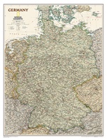 Wandkaart Duitsland, antiek, 60 x 77 cm | National Geographic
Complete political actual detail of Germany - country boundaries, roads and cities, airports, bodies of water, and other geographic details in antique style.
- 1
- 2
- 3
- Volgende >>
- 4
Waar moet je op letten als je een goede wandkaart van een land wilt kopen?
Welke verschillende soorten wandkaarten van landen zijn er eigenlijk: het kaartbeeld?
Verschillende projecties, hoe zit een wandkaart er uit?
Zijn er wandkaarten van alle landen beschikbaar?
Het formaat van een wandkaart van een land
De leesbaarheid van een wandkaart van een land
Veel uitvoeringen van dezelfde wandkaart van een land
Hoe wordt de wandkaart verzonden?
Laatste reviews

Fijne wegenkaart, alleen jammer dat dergelijke kaarten niet van een zodanige papiersoort worden vervaardigd, dat ze niet zo snel scheuren op de naden.
★★★★★ door Inge Stegeman 01 mei 2024 | Heeft dit artikel gekocht
Duidelijke en gedetailleerde plattegrond; goede aanvulling op google maps die noodzakelijkerwijs op postzegelformaat zijn. Er is wel een flink tafelblad nodig om hem uit te …
★★★★★ door Arjen Florijn 01 mei 2024 | Heeft dit artikel gekocht
De politieke wandkaart siert de wand, we reizen vanaf de bank mee met ons lieve familie.
★★★★★ door Willy Regter 01 mei 2024 | Heeft dit artikel gekocht
De atlas geeft de noodzakelijke wegeninformatie op een gedetailleerde schaal, zodat je je goed kunt oriënteren op de vaak lange, soms saaie trajecten. Betrouwbare gegevens …
★★★★★ door D. Van der Maas 01 mei 2024 | Heeft dit artikel gekocht