Mandje Tel: +31503126950 Menu
Winkelwagen
Geen items in winkelwagen
Ga naar winkelwagen

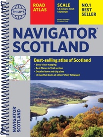
Wegenatlas Navigator Scotland | A4-Formaat | Ringband | Philip's Maps (9781849077033)

  • ISBN / CODE: 9781849077033
  • Editie: 2025
  • Druk: 7
  • Aantal blz.: 128
  • Schaal: 1:100000
  • Uitgever: Philip's Maps
  • Soort: Wegenatlas
  • Taal: Engels
  • Hoogte: 29.4 cm
  • Breedte: 22.0 cm
  • Dikte: 1.0 cm
  • Uitvoering: -
  • Bindwijze: RIngband
  • Beoordeling: 5,0 ★★★★★ (15 reviews) Schrijf een review
  • 14,95

    Op voorraad. Binnen 2 - 3 werkdagen in huis in Belgie Levertijd Nederland Voor 17.00 uur op werkdagen besteld, binnen 1 tot 2 werkdagen in huis in Nederland Levertijd Belgie

    Gratis verzending in Nederland vanaf €35,-

Beschrijving

Duidelijke en gedetailleerde atlas van Schotland met enkele stadsplattegronden en register.

Zuid Schotland is van schaal 1:100.000 en het noorden met schaal 1:200.000
 
Philip's Navigator Scotland is part of the Navigator brand, the UK's best-selling road atlases. The Navigator maps provide highly detailed coverage of the Scotland's road network, including minor country lanes and rural tracks. Most of the Central Lowlands and Scottish Borders are shown at the unique Navigator scale of 1.5 miles to 1 inch, Northern Scotland at 3 miles to 1 inch.
 
Navigator Scotland offers so much more than road maps: hundreds of individually named farms, houses and hamlets, airports, airfields, stations, ferries, canals, marinas, tourist information centres, and a wide range of places of interest. The atlas has a comprehensive index and includes indexed town plans of major regional centres. The front of the atlas contains a 15-page guide to regional leisure facilities and listings of a wide variety of activities from abseiling to yachting.
 
The atlas is ideal for touring with its large scale and wealth of travel information. The exceptional detail also makes the atlas ideal for local business use.
 
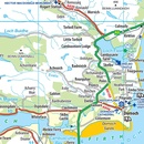
- Fully updated mapping at 1.5 miles to 1 inch = 1:100,000 (3 miles to 1 inch = 1:200,000 for Northern Scotland) 
- No other road atlas of Scotland offers this level of detail and clarity
- 15-page 'best places to visit' section, including sights and walks
- Practical A4 format with spiral binding
- 13 indexed town-centre maps
- Exceptional road detail, from motorways to country lanes, with every junction, roundabout and slip-road shown
- Thousands of individually named farms, houses and hamlets


Reviews

Perfecte kaart voor onderweg

Superfijne wegenatlas van Schotland met veel informatie in een handzaam formaat. Echt een aanrader als je rondreist.

★★★★★ door Remco Veldkamp 13 september 2024

Vond u dit een nuttige review? (login om te beoordelen)

-
Nee (0)
Super handige reis landkaart Schotland

Het gemak gedurende de hele vakantie van deze Navigator Schotland was echt top!

★★★★★ door Wim 8 juli 2024

Vond u dit een nuttige review? (login om te beoordelen)

-
Nee (0)
Geweldige kaart.

zeer handig en duidelijk.

★★★★★ door Jan Wijers 16 februari 2024

Vond u dit een nuttige review? (login om te beoordelen)

-
Nee (0)
Toon meer reviews

Schrijf een review

Graag horen wij wat u van dit artikel vindt. Vindt u het goed, leuk, mooi, slecht, lelijk, onbruikbaar of erg handig: schrijf gerust alles op! Het is niet alleen leuk om te doen maar u informeert andere klanten er ook nog mee!