
National Geographic
Dit bekende tv-kanaal heeft naast prachtige natuurdocumontaires en magazines ook zijn eigen reisgidsen en wegenkaarten uitgegeven. De landkaarten zijn gedrukt op scheurvast en waterbestendig papier wat een vergrootte levensduur betekent. De kaarten zijn helder en bevatten een schat aan informatie voor zowel de 'gewone' toerist als de avonturier. De hoofdwegen zijn duidelijk aangegeven, maar ook de secundaire wegen en tracks staan er op. Met de nationale parken duidelijk en mooie zwemplekken of attracties aangegeven onderscheidt deze kaartenserie zich van de andere wegenkaarten. De kaarten heten dan ook niet voor niets Adventure Maps! Het avontuur wacht!
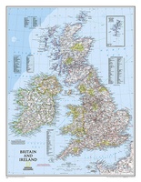 Wandkaart Britain and Ireland - Groot Brittannië en Ierland, 60 x 76 cm | National Geographic
This classic-style map of England and Wales shows political boundaries, major highways and roads, cities and towns, airports, and other geographic details. Thousands of place-names and exact borders are carefully …
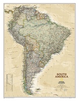 Wandkaart Zuid Amerika, politiek & antiek, 60 x 77 cm | National Geographic
This elegant, richly colored map of South America shows political boundaries, place names, airports, major roads and highways, and other geographic features for the entire continent.
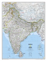 Wandkaart India, 60 x 77 cm | National Geographic
See India as only National Geographic can depict it. This new reference map is one of the most detailed and comprehensive ever published for India and southern Asia. It includes …
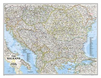 Wandkaart The Balkans - Balkan landen, 77 x 60 cm | National Geographic
Study the countries of the Balkans with our new map featuring the classic National Geographic reference styling. Features thousands of place names, accurate political boundaries, national parks, and major infrastructure …
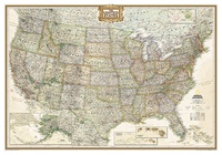 Wandkaart USA - Verenigde Staten Antiek, 111 x 77 cm | National Geographic
Wandkaart van de USA waarbij de kleuren in 'antieke' look zijn weergegeven, de staatgrenzen zeer duidelijk zijn en er veel plaatsen op staan. This Antique-style USA Wall Map by …
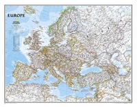 Wandkaart Europa, politiek, 77 x 60 cm | National Geographic
This colorful Europe political map clearly shows country boundaries, capitals, many major cities, bodies of water, airports, major highways and roads, and much more.
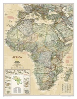 Wandkaart Afrika, politiek & antiek 61 x 78 cm | National Geographic
Mooie wandkaart van Afrika, staatkundig, met rustig kleurgebruik en helder kaartbeeld, Ondanks het wat kleiner formaat staan er toch heel wat topografische details op vermeld. Kaart is up-to-date, alleen …
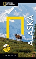 Reisgids Alaska | National Geographic
National Geographic Traveler: Alaska is the travel partner you need to organize a visit to the boundless uncontaminated spaces of "the Great Land" of Alaska, the largest American state, where …
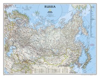 Wandkaart Russia – Rusland, 77 x 60 cm | National Geographic
Our classic wall map of Russia and the independent states of the former Soviet Union shows thousands of place names, roadways, political boundaries, bodies of water, airports, and many other …
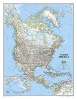 Wandkaart Noord Amerika, politiek, 91 x 118 cm | National Geographic
The political map of North America features trademark National Geographic detail and accuracy. The map shows country boundaries, place names, major highways and roads, bodies of water, and more. An …
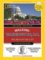 Wandelgids Walking Washington D.C. | National Geographic
Discover the best of Washington, D.C. with this handy guide, through 13 itineraries with step-by-step maps to help you explore its lively, eclectic neighborhoods. In a practical pocket format, the …
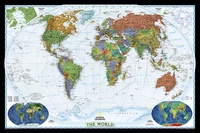 Wereldkaart Politiek, 108 x 75 cm | National Geographic
This map has spectacular color and detail to bring the world alive! Enjoy the accuracy and beauty of this world map, which features the Winkel Tripel projection to reduce distortion …
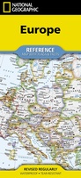 Wegenkaart - landkaart Europe - Europa | National Geographic
• Waterproof • Tear-Resistant • Reference Map Expertly researched and designed, National Geographic's Europe Flags & Facts Map is the authoritative map of Europe by which other reference maps …
 Wandkaart Noord Amerika, politiek, 60 x 77 cm | National Geographic
The political map of North America features trademark National Geographic detail and accuracy. The map shows country boundaries, place names, major highways and roads, bodies of water, and more. An …
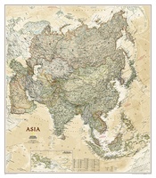 Wandkaart Azië, politiek & antiek, 84 x 96 cm | National Geographic
Mooie wandkaart van Azië, staatkundig, met rustig kleurgebruik en helder kaartbeeld; deze kaart heeft een antieke uitstraling door gebruik van aarde-kleuren. Ondanks het wat kleine formaat staan er toch heel …
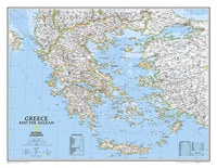 Wandkaart Greece – Griekenland, 77 x 60 cm | National Geographic
Decoratieve wandkaart van Griekenland. Naast de mooie kleuren staan er bijzonder veel plaatsen op vermeld. The classic National Geographic wall map of Greece shows this beautiful area in uncompromisingly accurate …
 Wegenatlas California Road and Recreation Atlas | National Geographic
From its expansive mountain ranges and vast deserts to its seemingly endless Pacific Coast, California is rich in geographical diversity and natural beauty. Explore The Golden State with this recently …
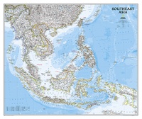 Wandkaart Zuidoost Azië, politiek, 96 x 81 cm | National Geographic
The Southeast Asia Political Map is a detailed reference map containing National Geographic’s clear visual presentation in a bright and appealing color palette. The map contains thousand of place names, …
Laatste reviews

Niet echt voor beginners. Ook zijn de routes soms moeilijk qua logistiek. Weer terugkomen aan het eind bv. En in voorseizoen (mei) blijft er niet …
★★★★★ door Tjeerd 17 mei 2024 | Heeft dit artikel gekocht
Van te voren had ik een andere kaart op het oog. Toen ik in de winkel was adviseerde zij mij deze kaart. Op hun verzoek …
★★★★★ door Koen 17 mei 2024 | Heeft dit artikel gekocht
Ideale schaal waar ook de kleinere wegen duidelijk zijn aangegeven. Beschrijving op website is correct.
★★★★★ door Peter 16 mei 2024 | Heeft dit artikel gekocht
Overzichtelijke kaart. Niks op aan te merken.
★★★★★ door Bastiaan de Leeuw 16 mei 2024 | Heeft dit artikel gekocht