Categorieën
- Nieuwe artikelen
- Boeken
-
Kaarten
- Camperkaarten
- Educatieve kaarten
- Fietskaarten
- Fietsknooppuntenkaarten
- Historische Kaarten
- Pelgrimsroutes (kaarten)
- Spoorwegenkaarten
- Stadsplattegronden
- Toerskikaarten
- Topografische kaarten
- Wandelatlassen
- Wandelkaarten
- Wandelknooppuntenkaarten
- Waterkaarten
- Wegenatlassen
-
Wegenkaarten
-
Afrika
- Algerije
- Angola
- Ascension
- Benin
- Botswana
- Burkina Faso
- Burundi
- Centraal Afrikaanse Republiek
- Demokratische Republiek Kongo
- Djibouti
- Egypte
- Eritrea
- Ethiopië
- Gabon
- Gambia
- Ghana
- Guinee
- Guinee - Bissau
- Ivoorkust
- Kaapverdische eilanden
- Kameroen
- Kenia
- Kongo
- Lesotho
- Liberia
- Libië
- Madagascar
- Malawi
- Mali
- Marokko
- Mauretanië
- Mauritius
- Mozambique
- Namibië
- Niger
- Nigeria
- Oeganda
- Reunion
- Rwanda
- Senegal
- Seychellen
- Sierra Leone
- Sint Helena
- Somalië
- Sudan
- Swaziland
- Tanzania
- Togo
- Tristan da Cunha
- Tsjaad
- Tunesië
- Zambia
- Zimbabwe
- Zuid-Afrika
- Azië
- Europa
- Midden-Amerika
- Midden-Oosten
- Noord-Amerika
- Oceanië
- Wereld
- Zuid-Amerika
-
Afrika
- Wintersportkaarten
- Opruiming
- Puzzels
- Travel Gadgets
- Wandkaarten
- Wereldbollen
Veilig online betalen
Betaal veilig via uw eigen bankomgeving
- U bent hier:
- Home
- Afrika
- Zuid-Afrika
- Kaarten
- Wegenkaarten
Geen items in winkelwagen
Ga naar winkelwagen
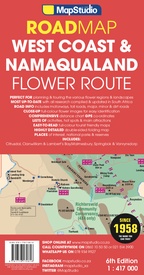
Wegenkaart - landkaart Flower Route: West Coast & Namaqualand NP | MapStudio (9781776170616)
- ISBN / CODE: 9781776170616
- Editie: 28-05-2024
- Druk: 6
- Aantal blz.: 1
- Schaal: 1:417000
- Uitgever: MapStudio
- Soort: Wegenkaart
- Taal: Engels
- Hoogte: 25.0 cm
- Breedte: 13.0 cm
- Bindwijze: -
- Uitvoering: Papier
- Schrijf als eerste een review
-
€ 16,95
Dit artikel is (tijdelijk) niet leverbaar Dit artikel is (tijdelijk) niet leverbaar
- Inkijkexemplaar
Beschrijving
Van de uitgever
Flower Route Road Map of the West Coast & Namaqualand is a detailed exploring map of the flower route region at a 1:417 000 scale, indicating flower watching areas.Provides information boxes on activities and facilities available in the region. Includes over 45 detailed flower identification photos with Latin names. Shows the entire route from Cape Town to the Namibian border includes: Richtersveld National Park, Namaqua National Park, West Coast National Park, Vanrynsdorp, Cederberg, Malmesbury, Lamberts Bay, Citrusdal, Clanwilliam and Springbok.
The map is double-sided and provides information supporting responsible land use and promotes tourism. Includes information on what to do in the West Coast listing attractions and contacts. Provides a route planner from the N7 to Route 27 and everything in between. GPS co-ordinates at major intersections.
Reviews
Geen reviews gevonden voor dit product.
Schrijf een review
Graag horen wij wat u van dit artikel vindt. Vindt u het goed, leuk, mooi, slecht, lelijk, onbruikbaar of erg handig: schrijf gerust alles op! Het is niet alleen leuk om te doen maar u informeert andere klanten er ook nog mee!
Alle gerelateerde rubrieken >
Ook interessant voor afrika/zuid-afrika
-

Wegenkaart - landkaart 8 Table Mount
€ 16,95Wegenkaarten Kaapstad -

Vogelgids Guide to birds of the Krug
€ 18,50Vogelgidsen Krugerpark -

Stadsplattegrond Walking Cape Town |
€ 13,95Stadsplattegronden Kaapstad -

Mountainbikegids Top MTB Trails 2 -
€ 18,95Mountainbikegidsen Zuid-Afrika -

Reisverhaal Somewhere Over the Rainb
€ 15,50Reisverhalen Zuid-Afrika


